Mining / Geotechnical / Environmental Engineering Software
 Rift TD is a sophisticated digital terrain model specifically developed for modelling tailings dams and
associated infrastructure, including embankments and ponds.
Rift TD is a sophisticated digital terrain model specifically developed for modelling tailings dams and
associated infrastructure, including embankments and ponds.
Rift TD allows the rapid assessment of various deposition scenarios and their impact on ponds, and the generation of staged earth-fill or time-staged cyclone embankment construction.
The software's capabilities include point, upstream, downstream and centreline deposition.
FEATURES [applications]
- Stand alone - Rift TD is not dependent on other software.
- Non-linear beach profiles.
- Cyclone deposition (Upstream, Downstream and Centreline Embankment).
- Tailings flow.
- Multiple material definitions.
- Multiple deposition point and/or deposition line definitions.
- Automatic or manual deposition - following model set-up, generating an elevation capacity curve is as easy as clicking a button.
- Pond volume elevation curve generation.
- Three D Viewing.
- DTM functionality.
For examples of some of Rift TD's Tailings Deposition Modelling capabilities see our Tutorial page.
Stand Alone
Rift TD is a stand alone package. It is not dependent on other software.
Data is imported/exported in either ASCII or DXF (Release 12) files.
Non Linear Beach Profiles 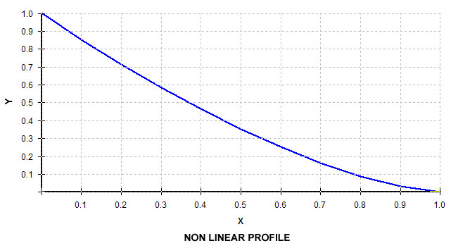
Model non-linear cyclone, sub-aerial and sub-aqueous beaches based on an overall slope and dimensionless profile. The profile is either entered manually or generated based on Blight and Bentals dimensionless profile (ref. The Master Profile for Hydraulic Fill Beaches, Proceedings of the Institution of Civil Engineering, Jan 1994).
Cyclone Deposition
For Upstream Cyclone deposition Rift TD estimates the cyclone/sub-aerial beach interface based on the underflow/overflow percentage split.
Downstream and Centreline Cyclone Embankments are modelled in a staged approach, with construction end times being determined based on a User specified underflow percentage. This approach allows the User to ascertain embankment crest elevations over time. Following the development of the model it is possible to do "what if" scenario testing to determine the effect of the underflow percentage and/or material densities.
Tailings Flow
Model tailings flow down valleys or around obstacles.
Multiple Materials
Model the deposition of multiple materials from different locations around the facility. Stage capacity curves are generated for each of the materials as well as for overall deposition.
Multiple Deposition Points
Define multiple deposition points and or deposition lines.
Deposition lines are drawn on the screen, and represent physical boundaries along which deposition takes place. Deposition points are generated along the boundaries based on user entered criteria (either a fixed number of deposition points, or a spacing between points). The Tailings Facility Wall can be developed to differing elevations along the length of the wall.
Once entered the user can specify the deposition sequence, enabling simultaneous deposition from a number of deposition points. This is of particular relevance to models containing a number of deposition materials.
Manual or Automatic Deposition
The user has complete control of deposition.
In automatic mode the facility is completely developed based on user input.
In manual mode the user specifies deposition elevations at deposition points. Deposition takes place from the points based on the user specified sequence.
Pond Generation
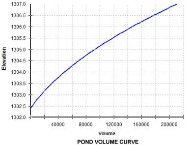
Generate ponds, and their volume elevation curves, by simply pointing to a point in the pond basin and entering the top water level.
Three D View
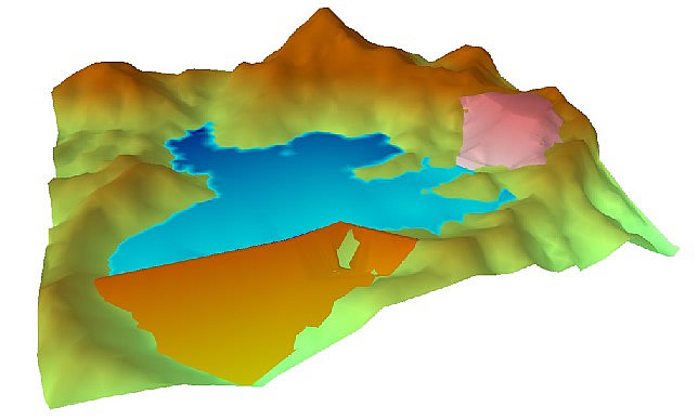
View the model in three dimensions from any angle - the model on this page was generated using Rift TD.
Alter lighting to accentuate the model.
View additional examples of models generated using Rift TD.
DTM Functionality
Rift TD has substantial DTM functionality:
- Generate multiple Surface Models.
- Generate earth walls.
- Determine cut and fill volumes between models.
- Generate long sections along strings.
- Generate cross sections along strings.
Numerous tools are available for editing the model:
- Add or remove points from the model graphically.
- Identify and manipulate nodes.
- Delete triangles in an area, along a line, or by pointing at them.
- Add triangles to the model by pointing and/or dragging.
An embankment wizard facilitates the task of embankment modelling.
APPLICATIONS [features]
TAILINGS DAM DESIGN
- Rapidly assess Tailings Storage Facility (TSF) basin volumes.
- Assess facility alternatives.
- Assess deposition strategies.
- Assess rate of rise over the life of the facility.
- Assess the final facility height.
- Assess the impact of sub-aerial and sub-aqueous beach profiles on the facility capacity.
- Estimate pond volume(s).
- Calculate embankment fill volumes.
TAILINGS DAM MANAGEMENT
- Predict pond locations and volumes.
- Determine remaining basin volume.
- Assess the effect of the deposition pattern on the pond.